January, 22nd 2018
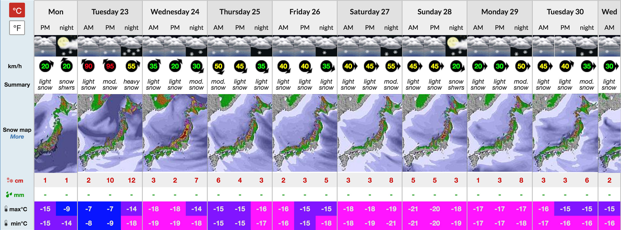
Niseko looks set to be blasted by another prolonged cold, snowy period over the coming week, and potentially longer.
With solid snowfall and temperatures expected to range between -15C to -20C for much of extended forecast period, we can expect excellent dry powder conditions.
The ultimate Niseko weather systems occur when a constant northwest airstream flows off Siberia, across the Sea of Japan, and onto Niseko, and remain for weeks at a time. Such an event occurred between mid-November and Christmas when it snowed on 27 out of 30 days after the resort opened on November 23.
Another bonus of this weather pattern is that winds are generally consistently light. This means there are fewer occasions when lifts need to go on wind hold than when short, wild storms blow through.
This current system doesn’t seem to be locked into such a holding pattern but fingers crossed we have a good few weeks of snow ahead.
So just as we hit the middle of peak season here in Niseko it looks like the winter of 2017/18 is going to keep on giving.
So far niseko.ne.jp’s official English language snow reporter 360niseko has recorded more than 8m of snow this season – with 6m of that being recorded before the end of 2017.
After a slower month, this bumper season looks set to continue, with cumulative snowfall looking to potentially 10m before January is out. Fasten your seatbelts!
Sign up to our newsletter in the box below to stay up to date with what’s going on in Niseko, and also have a chance to win a 5-day All Mountain lift pass every month!
Image source: Snow-Forecast.com
How Much Did It Snow In Niseko This Winter?
Skier Malou Peterson scored during her January trip at HANAZONO Niseko Winter 2025–26 asked for patience early, then rewarded us in cl...
28 May 2026
North America To Niseko Gets Easier This Winter
Niseko just got much closer for skiers and snowboarders from the US and Canada. Starting this winter, new direct flights will connect San ...
28 May 2026
Niseko Ramped Up Spring With A Series Of Events
As winter transitions into spring, Niseko continues to deliver unforgettable experiences both on and off the slopes. This season, the res...
29 April 2026
Niseko’s Late Spring: Ski Until May 6th, Enjoy Cherry Blossoms, And More
Days are getting warmer and the weather clearer in Niseko now that we are in the spring season. We have a little more than one week left in N...
27 April 2026
Niseko Opens Accommodation Bookings For Next Winter
Niseko properties have started to open their bookings for the 2026–27 ski season, with hotels, apartments, and chalets releasing availability...
31 March 2026
International Snow Event Just Put Niseko’s Spring On The Map – Swatch Nines
Niseko United stays open into early May, but after March the resort typically shifts into a quieter shoulder season. This year that is al...
27 February 2026
Peak Winter Delivers, Spring On The Horizon
Peak winter has delivered once again at Niseko United, reinforcing its reputation as one of the world’s premier powder destinations. As we mo...
26 January 2026
How To Maximize Your Niseko Experience
Niseko is more than just a ski destination. It’s a winter playground where legendary powder, exceptional dining, and unforgettable winter exp...
25 January 2026
Your Ultimate Guide to Getting Lift Passes at Niseko United
Niseko United is made up of four individual ski resorts, with a range of different lift passes depending on when and how long you want to ski...
23 December 2025
What You Miss If You Only Ski During the Day in Niseko
Niseko’s powder is legendary in the daytime, but at night, it creates a whole new dimension. When the floodlights take over from the sun at 4...
11 December 2025
What’s New This Winter in Niseko United 2025-26
As the mountains turn white once again, excitement is building for another unforgettable winter in Niseko United. From upgraded lifts and uni...
7 November 2025
Now, the Trail Map Is in Your Hand
A Smarter, Greener Way to Explore Niseko United This winter, exploring Niseko United just got easier – and greener. We’re excited to launc...
7 November 2025
How Not to Get Powder in Your Pants: What to Pack for Niseko’s Deep Snow
If you’ve skied places where powder is “occasional,” Niseko will feel brand new. Here, snow falls often and deep — which is awesome if ...
12 October 2025
Niseko Winter Forecast 2025–26: Above-Average Snowfall Expected
The mountains are calling – and Niseko’s forecast says it’s going to be an unforgettable winter. The Japan Meteorological Agency (JMA) has...
12 October 2025
Niseko United’s Winter Activities Beyond the Slopes
When you think of Niseko, you probably think about skiing or snowboarding perfect powder. But beyond the lifts and legendary snow, Niseko offers a wi...
28 September 2025
When Is the Best Time to Ski in Niseko? Season Breakdown
If you’ve already booked your Niseko trip, the next step is knowing what kind of season you’re stepping into. Each month has its own rhythm –...
28 September 2025
SUBSCRIBE TO OUR NEWSLETTER


Copyright © 2019 Niseko United.日本語